12
Dec 2024
13:59 UTC
Southern Africa Tactical: Meteorological services in Madagascar, Mozambique, Comoros issue alerts for Category 3 Tropical Cyclone Chido from December 13; avoid nonessential travel
Current Situation
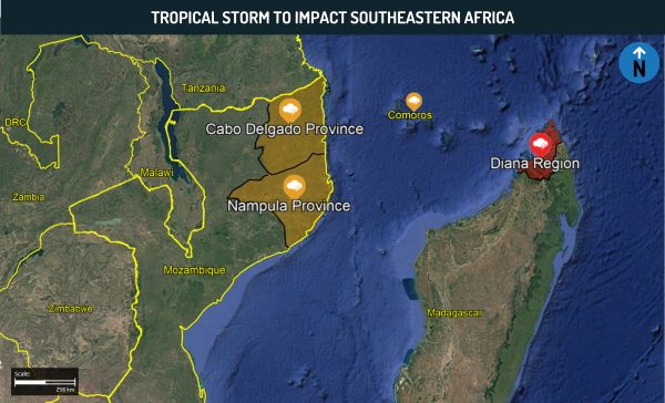
- According to official statements by the national meteorological services of Mozambique and Madagascar, tropical storm Chido is anticipated to reach northern Madagascar during the evening hours (local time) on December 13 and make landfall in Diana Region.
- It will then slightly weaken and proceed over the entire Comoros archipelago on December 14 before impacting northeastern Mozambique on December 14 as well. In Mozambique, the Nampula and Cabo Delgado provinces are expected to be affected.
- The meteorological services predicted the occurrence of moderate to heavy rainfall, accompanied by high waves and a high likelihood of flooding.
- As of writing, Chido is located approximately 500 km northeast of Madagascar’s coast, moving at an estimated speed of 18 km/h.
- According to Meteo Madagascar, the cyclone has recorded maximum sustained winds of 250 km/h. Chido evolved into a Category 3 Tropical Cyclone, on a scale of one to five, during the morning hours on December 12.
Source: INAM Statement
Recommendations
- Those operating or residing in Madagascar’s Diana Region, Comoros, and Mozambique’s Nampula and Cabo Delgado provinces on December 13 and over the following days are advised to take necessary precautions and remain cognizant of local updates regarding the inclement weather conditions.
- Allot for disruptions to traffic and public utilities, and reconfirm all flight and overland travel itineraries.
- Remain cognizant of the risks associated with outdoor travel. These include tree collapses onto roads and railway tracks, as well as electrocution caused by open circuits.
- Do not walk or drive through floodwaters. In case of flood warnings, immediately evacuate to higher ground. Once higher ground has been reached, do not attempt to evacuate the wider region alone and seek professional assistance with evacuations.
- Avoid contact with floodwater, including through bathing and drinking. Ensure adequate supply of bottled water; boil water before consumption as a last resort.
- Confirm that places of stay have working generators in case of power outages while packing sufficient batteries and flashlights.
- Charge essential electronic devices such as cellular phones, laptops, and tablet computers in advance due to potential power outages, and initiate energy-saving functions on these devices as needed. Disconnect all surge-prone devices such as computers, televisions, and appliances to prevent potential damage.
COUNTRY RISK LEVEL
Medium
AFFECTED AREA
Madagascar, Mozambique, Comoros
INCIDENT RISK LEVEL
High
STRENGTH OF SOURCE
Confirmed
Current Situation
- According to official statements by the national meteorological services of Mozambique and Madagascar, tropical storm Chido is anticipated to reach northern Madagascar during the evening hours (local time) on December 13 and make landfall in Diana Region.
- It will then slightly weaken and proceed over the entire Comoros archipelago on December 14 before impacting northeastern Mozambique on December 14 as well. In Mozambique, the Nampula and Cabo Delgado provinces are expected to be affected.
- The meteorological services predicted the occurrence of moderate to heavy rainfall, accompanied by high waves and a high likelihood of flooding.
- As of writing, Chido is located approximately 500 km northeast of Madagascar’s coast, moving at an estimated speed of 18 km/h.
- According to Meteo Madagascar, the cyclone has recorded maximum sustained winds of 250 km/h. Chido evolved into a Category 3 Tropical Cyclone, on a scale of one to five, during the morning hours on December 12.
Source: INAM Statement
Recommendations
- Those operating or residing in Madagascar’s Diana Region, Comoros, and Mozambique’s Nampula and Cabo Delgado provinces on December 13 and over the following days are advised to take necessary precautions and remain cognizant of local updates regarding the inclement weather conditions.
- Allot for disruptions to traffic and public utilities, and reconfirm all flight and overland travel itineraries.
- Remain cognizant of the risks associated with outdoor travel. These include tree collapses onto roads and railway tracks, as well as electrocution caused by open circuits.
- Do not walk or drive through floodwaters. In case of flood warnings, immediately evacuate to higher ground. Once higher ground has been reached, do not attempt to evacuate the wider region alone and seek professional assistance with evacuations.
- Avoid contact with floodwater, including through bathing and drinking. Ensure adequate supply of bottled water; boil water before consumption as a last resort.
- Confirm that places of stay have working generators in case of power outages while packing sufficient batteries and flashlights.
- Charge essential electronic devices such as cellular phones, laptops, and tablet computers in advance due to potential power outages, and initiate energy-saving functions on these devices as needed. Disconnect all surge-prone devices such as computers, televisions, and appliances to prevent potential damage.


